An Overview of Antire's Geography
The Geography of Antire
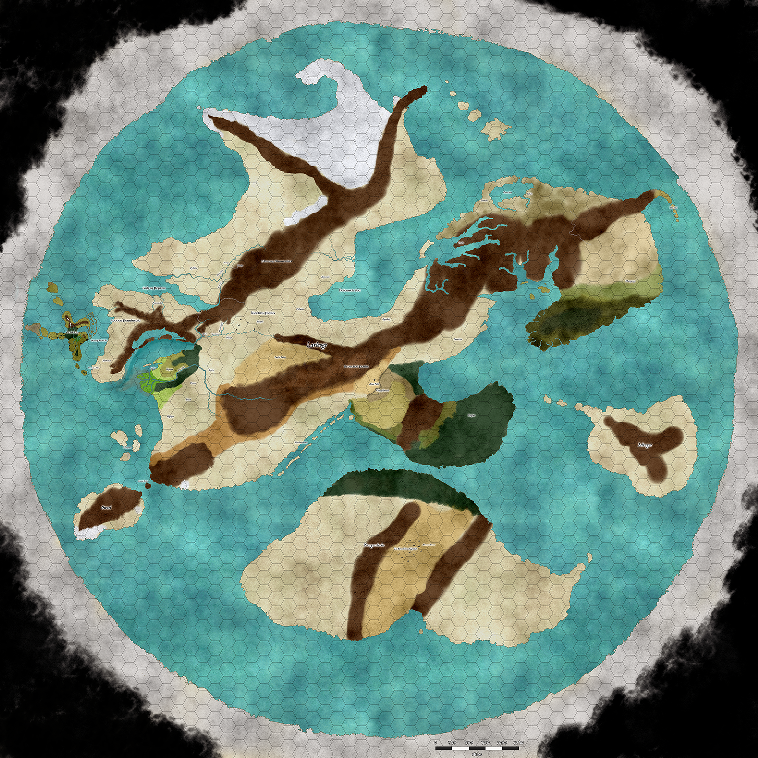
This is a draft of Antire created in Wonderdraft. For the non-blurry version of the map, go here. It's huge!
Continents and Archipelagos
Larleoge
The most common name for the great continent of Antire. It is so large that the peoples of Antire tend to refer to its subregions more often than the whole.
Geographic features of Larleoge
- Scorched Peaks - While not as high as the Platergs in terms of height from the plains around them, the mountains nearest the center of Antire come closest to the sun in its daily journey. Especially on their southward side, they are parched and inhospitable. At night, the peaks become intensely frigid. Only the hardiest creatures survive.
- Ashen Fields - Laying at the very center of Antire, this elevated plateau gets the most intense sunlight of the entire world. Little survives the daytime heat, nighttime cold, and generally parched conditions of this desert without outside help. This is a stony desert primarily composed of small stones worn down by the wind and daily scorch/freeze cycle into natural pavement. The stones are universally dark gray with light gray sand filling the spaces in between, hence the name “Ashen Fields.” Despite the harsh conditions, a variety of shrines compete and observatories huddle at the point recognized as the center of Antire. Each argues it occupies the point that is the “true” the center of the world. Low buildings with deep cellars and a few tall spires for observations are the sole shared features among the variety of architectural styles present.
- Valley of Derosie - laying south and below the rim of the escarpment that marks south east boundary of the Ashen Fields, the Valley lies mostly below sea level and is carved by gorges and ravines. The valley is arid, but hardy shrubs and grasses hold on. No city state or other government claims any part of the valley. The only inhabitants are a few brave souls who live alone or in small villages.
- Platerg Mountains - Forms the northern borders of Wlocyn and Sylwyria and the northern Heloratic Sea nations. North slopes of the highest, most rugged peaks tend to be glaciated and permanently snow covered as the sun never really reaches them.
- Rettien Peninsula or Rettia - The western most arm of Larleoge, host of the nations of Praemmden and Marvaux along with a group of city states who are constantly forming and reforming various alliances, leagues, and coalitions.
- Klothia - Catchall term for the regions west and north west of the Heloratic Sea nations. Includes the Klothian Plains, Platerg Mountains, Rettian Peninsula, and, by some reckonings, Oenklay.
- The Tail - A peninsula that turns into an archipelago at the far east of Larleoge, it is close enough to World’s Edge to see frequent visitations. The mountains separating it from the rest of Larleoge keep most of those monstrosities from reaching the rest of Larleoge. The result is overpopulation by those things from beyond the Edge. Attempts at settling The Tail inevitably fail. Not even pirates try to establish havens among its islands anymore.
Oenklay
Sometimes considered a continent, sometimes a very large archipelago. The furtherest reaches of Oenklay come closer to the World’s Edge than any other landmass, resulting in more visitations from the Other Realms than anywhere else in Antire. more:
Yungordorin
The southernmost and second largest continent. Dominated by the Alramun Desert, home of the lost Eleven Cities of Keridish.
Beltuguc
The third largest continent. The distance from any other part of Larleoge other than the isolationist city states of the forests of Xenghaus limits its contact with Antire as a whole.
Owesi
Only Oenklay is smaller and closer to the World’s Edge than Owesi. The stormy nature of the Straits of Resdve make it safer for ships to risk open ocean routes than the relatively short passage over the straits.
The Quarters
A group of four large islands north of Owesi.
Nations and Regions
Marvaux
Capital: Uhreville
Of the two western most peninsulas of the mainland that are commonly lumped together as the Rettien Peninsula, Marvaux occupies the southern and enjoys the most trade links with Oenklay out of all the mainland nations, especialy with Anealeas and secondarily with Oirnale.
Praemmden
Occupies much of the northern coast of the Rettien Peninsula. Enjoys trade links with Oenklay via Einea and Oirnale but this tradee is constrained by the pirates of Shatterend.
Pyellden
East of Paremmden, across the Gulf of Peprae. Shares much culture, myth and language Praemmden, although the dialects of are different enough that communication is often slow. Vast steppes and forests with few towns or cities beyond the banks of the Madouj and Orenouj Rivers make Pyellden a wild place. more:
Wlocyn
Capital: Zofnifc
East-north east of Bizuena. Enjoys generally peaceful relations with Bizuena, but every generation or so tensions mount as Wlocyn tries to claim the mouth of the River Aboyje below Zofnifc.
Sylwyria
Landlocked nation east-north east of Wlocyn and in a perpetual low level border war as Wlocyn blocks its access down the lower reaches of the River Aboyje to the sea. The Rivers Aboyje and Whewethy separate the two nations. They are guarded by multiple watchtowers, castles, and even the banks are walled in some places.
Bizuena
Capital: Caralata
The largest and most prosperous nation on the western coasts of Larleoge if one does not count Wlocyn, Bizuena is a mix of ferile plain, woodland, and marsh. Deep forests protect much of its border while twin fortress cities protect the approach along the Diawe River.
The Merchant Coast
This long stretch of the southwestern coast of Larleoge is filled by many small nations grown out of independent cities who use trade and espionage as their means of getting ahead of one another. The mostly mild climate, long distance to the World’s Edge, and sea routes sheltered by an archipelago of island volcanoes would make this an ideal area for civilization to flourish if not for the frequent eruptions, earthquakes, and tsunamis.
Bodies of Water
- Gulf of Peprae - The large, deep sea separating Pyellden from Praemmden. Pirates from the Shatterend sometimes prey in the western reaches.
- Sea of Rettia or Rettien Sea - The segment of the world ocean that separates Oenklay from the Rettien Peninsula.
- The Straits of Resdve - The mixing of oddly cold water and warm water makes this passage difficult and risky.
- Madouj River - The main river of Pyellden. Navigable by smaller seaworthy vessels as far as Bacompy where the Great Falls of the Madouj force a portage.
- Orenouj River (Oh-reh-new-zh) - The second major river of Pyellden. While shorter than the Madouj, it provides quick access to the interior of the Platerg Mountains and thus sees nearly as much traffic.
- Diawe River (Die-aw-wah) - The principal river of Bizuena and possibly the longest in all of Antire, the trade up and down this river from the landlocked nations and settlements of Larleoge’s interior helps fuel Bizuena’s economy.
- River Aboyje (Ah-boy-zh) - The longest, and most navigable river draining the Klothian plains, the enmity between Wroclyn and Sylwyria greatly reduce the trade that no doubt otherwise use this river as its highway. Sylwyria refuses to allow vessels that do not have Sylwyrian pilots on board to dock on its shores and Wroclyn refuses to let vessels dock on its ports or pass into the lower reaches it completely controls if they do have a Sylwyrian pilot on board. The result is that trade from the Heloratic Sea nations ends up taking land routes over the mountains and through the Laufer Desert to reach Wroclyn.
Languages
- Pellpi - shared base language between Pyellden and Praemmden. Wild regional variations can seem perplexing to outsiders , but native speakers will have few issues.
- Klothian - Language of the Klothian Plains, shared with some variations between Vithunia, Sylwyria, and Wlocyn.
Peoples
- Black Heart - One of the kobold cultures that inhabits subterranean and wild Oenklay. Now divided into separate bands, the once unified nation played a key role in the Pestilence and is now the most reviled people of the only species consistently reviled throughout the cosmopolitan Oenklay.
- Ketlaskee - a confederation of firbolg villages in the area of Hishadyn. Well, I call them firbolg now. Big people.